
"Sight seeing"
Sightseeing
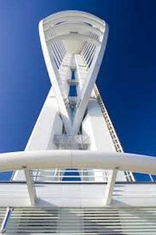
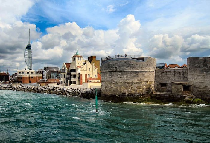
The Spinnaker Tower is a 170-metre (560 ft) landmark observation tower in Portsmouth, England, UK. It is the centrepiece of the redevelopment of Portsmouth Harbour, which was supported by a National Lottery grant. Its shape was chosen by Portsmouth residents from a selection. The tower, designed by local firm HGP Architects and engineering consultants Scott Wilson and built by Mowlem, reflects Portsmouth's maritime history through its being modelled and named after a spinnaker, a type of sail that balloons outward. The tower was opened on 18 October 2005.
The tower, at a height of 560 feet (170 m), is 2 1⁄2 times as high as Nelson's Column, making it one of the tallest accessible structures in the United Kingdom outside London. The tower is visible around Portsmouth, changing the horizon of the area. It can be seen from the Isle of Wight, the Manhood Peninsula and even Highdown Gardens in Worthing.
The tower represents sails billowing in the wind, a design accomplished using two large, white, sweeping metal arcs, which give the tower its spinnaker sail design. The steelwork was fabricated by Butterley Engineering. At the top is a triple observation deck, providing a 360° view of the city of Portsmouth, the Langstone and Portsmouth harbours, and a viewing distance of 23 miles (37 km). The highest of the three observation platforms, the Sky Deck, has only a wire mesh roof, so visitors are open to the elements. The windows extend above head height, so it is not possible to get a view unobstructed by glass. A glass floor is located on the first viewing deck at 100 metres above sea level. The tower has a design lifetime of 80 years.
The entry fees are usually £8.00(adults) and £7.15(OAP's)but if you search the internet before you go it is possible to obtain coupons giving you a 20% discount off the full price, such as from the 'My Voucher Codes' website so you will only pay a total of £12.10 for the entrance fee as opposed to the full price of £15.15 , so don't forget to seek out and print your vouchers before you go and save yourselves some of your hard earned money!
You can buy a guide book when you pay for your admission tickets at the entry cash desk which costs £3.50.
Access to the two higher floors is by short staircases from the first level and the centre level houses the cafe where you can sit down at the tables which are sensibly arranged around the perimeter of the room in order to allow visitors to enjoy the glorious views. At first perhaps £5.50 for two coffees may seem expensive, but bearing in mind the unique location and the views, coupled with the fact that there are even loos at this great height which are provided with hot water, it is good value for money, and no pressure is placed upon you to vacate the table.
I estimate that perhaps two to three hours would be sufficient time to allow for a visit to the Spinnaker Tower together with time to enjoy a coffee in the cafe.
The 'Spinnaker Tower' is most certainly an attraction not to miss, and the views from it are unbeatable.
I consider the 'Spinnaker Tower' to be a 'Fair Weather Attraction,' and I would suggest that potential visitors consider going only on clear dry sunny days, otherwise the views might well be restricted due to cloud, fog, rain and sea mists etc.
Oh yes! - one other thing.....don't forget to take your binoculars because you really will need them to get the most out of your visit.
148 người dân địa phương đề xuất
Tháp Spinnaker
The Spinnaker Tower is a 170-metre (560 ft) landmark observation tower in Portsmouth, England, UK. It is the centrepiece of the redevelopment of Portsmouth Harbour, which was supported by a National Lottery grant. Its shape was chosen by Portsmouth residents from a selection. The tower, designed by local firm HGP Architects and engineering consultants Scott Wilson and built by Mowlem, reflects Portsmouth's maritime history through its being modelled and named after a spinnaker, a type of sail that balloons outward. The tower was opened on 18 October 2005.
The tower, at a height of 560 feet (170 m), is 2 1⁄2 times as high as Nelson's Column, making it one of the tallest accessible structures in the United Kingdom outside London. The tower is visible around Portsmouth, changing the horizon of the area. It can be seen from the Isle of Wight, the Manhood Peninsula and even Highdown Gardens in Worthing.
The tower represents sails billowing in the wind, a design accomplished using two large, white, sweeping metal arcs, which give the tower its spinnaker sail design. The steelwork was fabricated by Butterley Engineering. At the top is a triple observation deck, providing a 360° view of the city of Portsmouth, the Langstone and Portsmouth harbours, and a viewing distance of 23 miles (37 km). The highest of the three observation platforms, the Sky Deck, has only a wire mesh roof, so visitors are open to the elements. The windows extend above head height, so it is not possible to get a view unobstructed by glass. A glass floor is located on the first viewing deck at 100 metres above sea level. The tower has a design lifetime of 80 years.
The entry fees are usually £8.00(adults) and £7.15(OAP's)but if you search the internet before you go it is possible to obtain coupons giving you a 20% discount off the full price, such as from the 'My Voucher Codes' website so you will only pay a total of £12.10 for the entrance fee as opposed to the full price of £15.15 , so don't forget to seek out and print your vouchers before you go and save yourselves some of your hard earned money!
You can buy a guide book when you pay for your admission tickets at the entry cash desk which costs £3.50.
Access to the two higher floors is by short staircases from the first level and the centre level houses the cafe where you can sit down at the tables which are sensibly arranged around the perimeter of the room in order to allow visitors to enjoy the glorious views. At first perhaps £5.50 for two coffees may seem expensive, but bearing in mind the unique location and the views, coupled with the fact that there are even loos at this great height which are provided with hot water, it is good value for money, and no pressure is placed upon you to vacate the table.
I estimate that perhaps two to three hours would be sufficient time to allow for a visit to the Spinnaker Tower together with time to enjoy a coffee in the cafe.
The 'Spinnaker Tower' is most certainly an attraction not to miss, and the views from it are unbeatable.
I consider the 'Spinnaker Tower' to be a 'Fair Weather Attraction,' and I would suggest that potential visitors consider going only on clear dry sunny days, otherwise the views might well be restricted due to cloud, fog, rain and sea mists etc.
Oh yes! - one other thing.....don't forget to take your binoculars because you really will need them to get the most out of your visit.
The Normandy landings were the landing operations on Tuesday, 6 June 1944 of the Allied invasion of Normandy in Operation Overlord during World War II. Codenamed Operation Neptune and often referred to as D-Day, it was the largest seaborne invasion in history.
46 người dân địa phương đề xuất
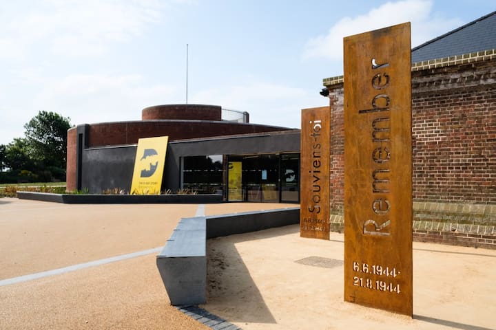
Bảo tàng Ngày D
Clarence EsplanadeThe Normandy landings were the landing operations on Tuesday, 6 June 1944 of the Allied invasion of Normandy in Operation Overlord during World War II. Codenamed Operation Neptune and often referred to as D-Day, it was the largest seaborne invasion in history.
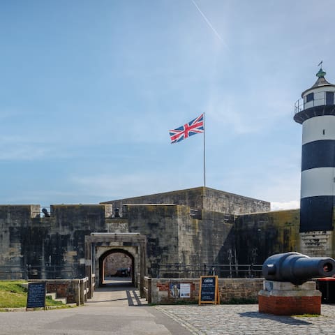
Southsea Castle was one in a series of forts constructed for King Henry VIII, in what was the most ambitious scheme of coastal defence since Roman times. Free entrance to the public. There is a lighthouse, a restaurant and a micro-brewery inside!
Southsea Castle, historically also known as Chaderton Castle, South Castle and Portsea Castle, is an artillery fort originally constructed by Henry VIII on Portsea Island, Hampshire, in 1544. It formed part of the King's Device programme to protect against invasion from France and the Holy Roman Empire, and defended the Solent and the eastern approach to Portsmouth. The castle had a square central keep, two rectangular gun platforms to the east and west, and two angled bastions to the front and rear, and was an early English example of the trace italienne-style of fortification popular on the Continent. The Cowdray engraving of the Battle of the Solent in 1545 depicted Henry VIII visiting the castle. Despite several serious fires, it remained in service and saw brief action at the start of the English Civil War in 1642 when it was stormed by Parliamentary forces.
The castle was expanded in the 1680s by Sir Bernard de Gomme and, after a period of neglect in the 18th century, was redesigned again in 1814 during the Napoleonic Wars. After a brief period of use as a military prison in the 1840s, the fortification was expanded in the 1850s and 1860s with additional gun batteries on the east and west sides. The defences were upgraded throughout the century due to the fears of a French invasion and formed part of the plan for defending Portsmouth during the First World War. In the interwar years some of the fortifications were stood down, but the castle saw service again in the Second World War, when it was involved in Operation Grasp, the seizure of French naval vessels in Portsmouth harbour. In 1960, Southsea Castle, by now obsolete, was sold to Portsmouth City Council. It was restored to its pre-1850 appearance and opened as a tourist attraction, receiving over 90,000 visitors from 2011–12.
76 người dân địa phương đề xuất
Lâu đài Southsea
Clarence EsplanadeSouthsea Castle was one in a series of forts constructed for King Henry VIII, in what was the most ambitious scheme of coastal defence since Roman times. Free entrance to the public. There is a lighthouse, a restaurant and a micro-brewery inside!
Southsea Castle, historically also known as Chaderton Castle, South Castle and Portsea Castle, is an artillery fort originally constructed by Henry VIII on Portsea Island, Hampshire, in 1544. It formed part of the King's Device programme to protect against invasion from France and the Holy Roman Empire, and defended the Solent and the eastern approach to Portsmouth. The castle had a square central keep, two rectangular gun platforms to the east and west, and two angled bastions to the front and rear, and was an early English example of the trace italienne-style of fortification popular on the Continent. The Cowdray engraving of the Battle of the Solent in 1545 depicted Henry VIII visiting the castle. Despite several serious fires, it remained in service and saw brief action at the start of the English Civil War in 1642 when it was stormed by Parliamentary forces.
The castle was expanded in the 1680s by Sir Bernard de Gomme and, after a period of neglect in the 18th century, was redesigned again in 1814 during the Napoleonic Wars. After a brief period of use as a military prison in the 1840s, the fortification was expanded in the 1850s and 1860s with additional gun batteries on the east and west sides. The defences were upgraded throughout the century due to the fears of a French invasion and formed part of the plan for defending Portsmouth during the First World War. In the interwar years some of the fortifications were stood down, but the castle saw service again in the Second World War, when it was involved in Operation Grasp, the seizure of French naval vessels in Portsmouth harbour. In 1960, Southsea Castle, by now obsolete, was sold to Portsmouth City Council. It was restored to its pre-1850 appearance and opened as a tourist attraction, receiving over 90,000 visitors from 2011–12.
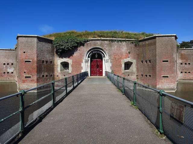
The Round Tower. Broad Street, Old Portsmouth, Hampshire, PO1 2JE.
For hundreds of years, Portsmouth’s importance as a naval base meant that it was one of the most heavily defended cities in Europe. The Round Tower was the first of a series of permanent fortifications that were built in Portsmouth over the centuries.
Work on the Round Tower was begun in about 1418, and it was completed in the 1420s. Before 1400, Portsmouth had been attacked and burnt several times by the French during the Hundred Years War. The Tower was intended to defend the entrance to the Harbour and prevent enemy ships from entering. It was not built specifically to defend the town.
At the time it was built, the Round Tower was actually outside the town walls, on the small peninsula known as Point. The nearest gate into Portsmouth – Point Gate, later known as King James’ Gate – was roughly halfway along Broad Street between the Round Tower and the nearby Square Tower (built 1494). The Dockyard as we know it did not exist, and the King’s ships were moored in The Camber, the small harbour that today is mainly used by fishing boats.
At first the Round Tower was known as “Master Ridley’s Tower”, after John Ridley who in 1536 had been put in charge of it and other royal buildings in the town. Like most fortifications, the Round Tower has been modified many times in its history.
In the reign of Queen Elizabeth I (1558-1603) it was rebuilt with six gun ports for cannons, three of which have since been filled in (to the left of the existing gun ports, as seen from inside the Tower). The Tower has always been at risk of being undermined by the sea. In the reign of Elizabeth I, all boats that regularly went back and forth between the Isle of Wight and Portsmouth had to deposit a boatload of stones around its base.
The Tower was extended in height shortly before 1815, and again in 1850 to bring it to its present height of 35 ft (11 m). The interior of the Tower as seen today dates from the period of the Napoleonic Wars (before 1815) when the central column and brick vaulting were added to support the weight of guns on the roof. The stalactites growing from the ceiling are due to minerals being washed out of the mortar holding the bricks together.
As an additional defence, an iron chain could be stretched across the Harbour mouth from Capstan Square next to the Round Tower, over to the Gosport side, where a wooden tower was built at around the same time as the Round Tower. This chain boom was used for hundreds of years, with the chain being replaced at intervals, and a similar defence was even in place during the Second World War. Two original links from one of these chains can be seen in Southsea Castle (a replica link is also on display in Capstan Square).
In front of the Round Tower is a rock that was brought back to Portsmouth on board HMS Hecla. The inscription on the rock reads "During the Russian War (1854) a landing party from HMS HECLA was attacked by a large body of Cossacks and many would have fallen had it not been for the courage of two sailors who taking cover behind this stone kept the enemy at bay until the safety of the whole party was assured. Captain HALL had this boulder carried to his ship and transported to Portsmouth. "
9 người dân địa phương đề xuất
Tháp tròn
Broad StreetThe Round Tower. Broad Street, Old Portsmouth, Hampshire, PO1 2JE.
For hundreds of years, Portsmouth’s importance as a naval base meant that it was one of the most heavily defended cities in Europe. The Round Tower was the first of a series of permanent fortifications that were built in Portsmouth over the centuries.
Work on the Round Tower was begun in about 1418, and it was completed in the 1420s. Before 1400, Portsmouth had been attacked and burnt several times by the French during the Hundred Years War. The Tower was intended to defend the entrance to the Harbour and prevent enemy ships from entering. It was not built specifically to defend the town.
At the time it was built, the Round Tower was actually outside the town walls, on the small peninsula known as Point. The nearest gate into Portsmouth – Point Gate, later known as King James’ Gate – was roughly halfway along Broad Street between the Round Tower and the nearby Square Tower (built 1494). The Dockyard as we know it did not exist, and the King’s ships were moored in The Camber, the small harbour that today is mainly used by fishing boats.
At first the Round Tower was known as “Master Ridley’s Tower”, after John Ridley who in 1536 had been put in charge of it and other royal buildings in the town. Like most fortifications, the Round Tower has been modified many times in its history.
In the reign of Queen Elizabeth I (1558-1603) it was rebuilt with six gun ports for cannons, three of which have since been filled in (to the left of the existing gun ports, as seen from inside the Tower). The Tower has always been at risk of being undermined by the sea. In the reign of Elizabeth I, all boats that regularly went back and forth between the Isle of Wight and Portsmouth had to deposit a boatload of stones around its base.
The Tower was extended in height shortly before 1815, and again in 1850 to bring it to its present height of 35 ft (11 m). The interior of the Tower as seen today dates from the period of the Napoleonic Wars (before 1815) when the central column and brick vaulting were added to support the weight of guns on the roof. The stalactites growing from the ceiling are due to minerals being washed out of the mortar holding the bricks together.
As an additional defence, an iron chain could be stretched across the Harbour mouth from Capstan Square next to the Round Tower, over to the Gosport side, where a wooden tower was built at around the same time as the Round Tower. This chain boom was used for hundreds of years, with the chain being replaced at intervals, and a similar defence was even in place during the Second World War. Two original links from one of these chains can be seen in Southsea Castle (a replica link is also on display in Capstan Square).
In front of the Round Tower is a rock that was brought back to Portsmouth on board HMS Hecla. The inscription on the rock reads "During the Russian War (1854) a landing party from HMS HECLA was attacked by a large body of Cossacks and many would have fallen had it not been for the courage of two sailors who taking cover behind this stone kept the enemy at bay until the safety of the whole party was assured. Captain HALL had this boulder carried to his ship and transported to Portsmouth. "
Portsdown Hill provides magnificent views over Portsmouth and beyond. The slopes are home to impressive shows of wildlife that can be explored through miles of paths.
Portsdown Hill is a chalk ridge that overlooks Portsmouth and provides a stunning viewpoint over the city, the harbours and over to the Isle of Wight. The hill's open network of paths take walkers through flowery grassland and other wildlife-rich habitats.
Much of Portsdown's extensive chalk grassland is a Site of Special Scientific Interest. The grassland is home to fantastic displays of colourful wildflowers that change through the spring, summer and autumn. It is an excellent place to spot bees, butterflies and hundreds of other pollinating insects. This flower-rich grassland is now a rare habitat as most has been lost from the countryside.
The hill is also rich in bird life, with species such as yellowhammers and whitethroats singing from the bushes, as well as skylarks floating above the waving grassland. Kestrels and Peregrines are present all year and nest on the site.
Evidence of our ancestors is everywhere and history, especially military history, is hard to miss. Museums are on hand in some of the Victorian forts to help tell the story.
The hill is well served by public transport from Portsmouth and has ample free parking.
Worth a trip if only to see Portsmouth lit in all her glory at night, or to grab a burger from Mick's Monster Burger van (see about that in my food section).
12 người dân địa phương đề xuất

Portsdown Hill Viewpoint
Portsdown Hill RoadPortsdown Hill provides magnificent views over Portsmouth and beyond. The slopes are home to impressive shows of wildlife that can be explored through miles of paths.
Portsdown Hill is a chalk ridge that overlooks Portsmouth and provides a stunning viewpoint over the city, the harbours and over to the Isle of Wight. The hill's open network of paths take walkers through flowery grassland and other wildlife-rich habitats.
Much of Portsdown's extensive chalk grassland is a Site of Special Scientific Interest. The grassland is home to fantastic displays of colourful wildflowers that change through the spring, summer and autumn. It is an excellent place to spot bees, butterflies and hundreds of other pollinating insects. This flower-rich grassland is now a rare habitat as most has been lost from the countryside.
The hill is also rich in bird life, with species such as yellowhammers and whitethroats singing from the bushes, as well as skylarks floating above the waving grassland. Kestrels and Peregrines are present all year and nest on the site.
Evidence of our ancestors is everywhere and history, especially military history, is hard to miss. Museums are on hand in some of the Victorian forts to help tell the story.
The hill is well served by public transport from Portsmouth and has ample free parking.
Worth a trip if only to see Portsmouth lit in all her glory at night, or to grab a burger from Mick's Monster Burger van (see about that in my food section).
The Hovercraft Museum, located in Lee-on-the-Solent in Hampshire, England, is a museum run by a registered charity dedicated to hovercraft.
The museum has a large collection of over 60 hovercraft of various designs. Situated at HMS Daedalus by the large slipway from where many hovercraft have been tested, the museum collection includes SR.N5 and SR.N6 hovercraft. The collection also contains the last remaining SR.N4 craft, the world's largest civil hovercraft, which has been laid up in Lee-on-the-Solent since cross-Channel services ceased on 1 October 2000.
The museum houses the world's largest library of documents, publications, film, video, photographs and drawings on hovercraft, all of which is available for research by prior arrangement. A number of hovercraft manufacturers have deposited their complete archives with the museum for safekeeping, thus swelling this important repository of information.
The museum also contains a large collection of original manufacturers' hovercraft models including the world's first working hovercraft model built by Christopher Cockerell.
20 người dân địa phương đề xuất
Hovercraft Museum
Marine Parade WestThe Hovercraft Museum, located in Lee-on-the-Solent in Hampshire, England, is a museum run by a registered charity dedicated to hovercraft.
The museum has a large collection of over 60 hovercraft of various designs. Situated at HMS Daedalus by the large slipway from where many hovercraft have been tested, the museum collection includes SR.N5 and SR.N6 hovercraft. The collection also contains the last remaining SR.N4 craft, the world's largest civil hovercraft, which has been laid up in Lee-on-the-Solent since cross-Channel services ceased on 1 October 2000.
The museum houses the world's largest library of documents, publications, film, video, photographs and drawings on hovercraft, all of which is available for research by prior arrangement. A number of hovercraft manufacturers have deposited their complete archives with the museum for safekeeping, thus swelling this important repository of information.
The museum also contains a large collection of original manufacturers' hovercraft models including the world's first working hovercraft model built by Christopher Cockerell.
I have noticed that a number of my visitors (particularly from abroad) choose to visit Stonehenge, and because it is actually quite easy to get to I have included it here. The National Express coach for the Hard interchange drops you off at Salisbury where you can hop on a sightseeing bus tour - which includes a couple of other attractions in the area! Details of doing this are in my blue boxfile.
Stonehenge is a prehistoric monument in Wiltshire, England, two miles (3 km) west of Amesbury. It consists of a ring of standing stones, with each standing stone around 13 feet (4.0 m) high, seven feet (2.1 m) wide and weighing around 25 tons. The stones are set within earthworks in the middle of the most dense complex of Neolithic and Bronze Age monuments in England, including several hundred burial mounds.
Archaeologists believe it was constructed from 3000 BC to 2000 BC. The surrounding circular earth bank and ditch, which constitute the earliest phase of the monument, have been dated to about 3100 BC. Radiocarbon dating suggests that the first bluestones were raised between 2400 and 2200 BC, although they may have been at the site as early as 3000 BC.
One of the most famous landmarks in the United Kingdom, Stonehenge is regarded as a British cultural icon. It has been a legally protected Scheduled Ancient Monument since 1882 when legislation to protect historic monuments was first successfully introduced in Britain. The site and its surroundings were added to UNESCO's list of World Heritage Sites in 1986. Stonehenge is owned by the Crown and managed by English Heritage; the surrounding land is owned by the National Trust.
Stonehenge could have been a burial ground from its earliest beginnings. Deposits containing human bone date from as early as 3000 BC, when the ditch and bank were first dug, and continued for at least another five hundred years.
677 người dân địa phương đề xuất

Stonehenge
I have noticed that a number of my visitors (particularly from abroad) choose to visit Stonehenge, and because it is actually quite easy to get to I have included it here. The National Express coach for the Hard interchange drops you off at Salisbury where you can hop on a sightseeing bus tour - which includes a couple of other attractions in the area! Details of doing this are in my blue boxfile.
Stonehenge is a prehistoric monument in Wiltshire, England, two miles (3 km) west of Amesbury. It consists of a ring of standing stones, with each standing stone around 13 feet (4.0 m) high, seven feet (2.1 m) wide and weighing around 25 tons. The stones are set within earthworks in the middle of the most dense complex of Neolithic and Bronze Age monuments in England, including several hundred burial mounds.
Archaeologists believe it was constructed from 3000 BC to 2000 BC. The surrounding circular earth bank and ditch, which constitute the earliest phase of the monument, have been dated to about 3100 BC. Radiocarbon dating suggests that the first bluestones were raised between 2400 and 2200 BC, although they may have been at the site as early as 3000 BC.
One of the most famous landmarks in the United Kingdom, Stonehenge is regarded as a British cultural icon. It has been a legally protected Scheduled Ancient Monument since 1882 when legislation to protect historic monuments was first successfully introduced in Britain. The site and its surroundings were added to UNESCO's list of World Heritage Sites in 1986. Stonehenge is owned by the Crown and managed by English Heritage; the surrounding land is owned by the National Trust.
Stonehenge could have been a burial ground from its earliest beginnings. Deposits containing human bone date from as early as 3000 BC, when the ditch and bank were first dug, and continued for at least another five hundred years.
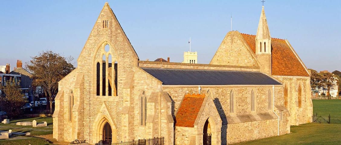
Royal Garrison Church was built in about 1212 by the Bishop of Winchester as part of a hospital and hostel for pilgrims. Used as an ammunition store after the Reformation, it became part of the governor of Portsmouth’s house during Elizabeth I’s reign. The church was restored in the 19th century, and although the nave was badly damaged in a 1941 firebomb raid on Portsmouth, the chancel is still roofed and furnished. Fine 20th-century stained-glass windows depict scenes from the Second World War and from the church’s own history.
7 người dân địa phương đề xuất
Royal Garrison Church
Royal Garrison Church was built in about 1212 by the Bishop of Winchester as part of a hospital and hostel for pilgrims. Used as an ammunition store after the Reformation, it became part of the governor of Portsmouth’s house during Elizabeth I’s reign. The church was restored in the 19th century, and although the nave was badly damaged in a 1941 firebomb raid on Portsmouth, the chancel is still roofed and furnished. Fine 20th-century stained-glass windows depict scenes from the Second World War and from the church’s own history.
https://solentforts.com/horse-sand-fort/
Horse Sand Fort is one of the larger Royal Commission sea forts in the Solent off Portsmouth, Hampshire, England. The fort is one of four built as part of the Palmerston Forts constructions. It is 200 feet (61 m) across, built between 1865 and 1880, with two floors and a basement and armour-plated all round.
Horse Sand Fort was designed by Captain E. H. Stewart, overseen by Assistant Inspector General of Fortifications, Colonel W. F. D. Jervois. Construction work began in 1865, and the fort was completed in 1880, long after the threat of a seaborne invasion from France had passed, at a cost of £424,694.
The original armament was to have been forty five 10-inch and 44 12.5-inch rifled muzzle-loading (RML) guns on the gun floors with 10 12-inch RMLs mounted on the roof in five turrets. In fact the turrets were never built and the limited space meant the 12.5-inch guns had to be operated with less than full charges of powder. In 1882, 12-inch rifled breech-loading guns were placed in alternate bays.
Horse Sand Fort was built on a ring of masonry consisting of large concrete blocks with an outer skin of granite blocks, the interior being filled with clay and shingle and covered with a thick layer of concrete. The lower foundation walls of the fort are 18 metres (59 ft) thick. The fort is split into three levels with the top measuring 62.4 metres (204 ft 9 in) in diameter. The floors would have originally provided storage of armoury and guns and the things needed to sustain the men that were stationed on site. The top of the fort consisted of a lighthouse and various chimneys and ventilators. The fort has its own artesian well which provided fresh water. The seaward side of the fort was covered in a heavy iron-armoured plating to protect it from seaborne attack. Access to the fort was by a wooden-decked landing stage supported on cast-iron piles.
6-inch Breech Loading (BL) gun on top of Horse Sand Fort, 1940 (IWM H 4618)
In the late 19th century the Solent forts were painted in a black and white checkered paint scheme as an early form of dazzle camouflage. In its unrestored state remains of this pattern are still visible on parts of Horse Sand Fort.
During the Second World War extensive submarine defences were built in the form of large concrete blocks running about 1.8 metres (5.9 ft) below sea level from the fort to the shore at Southsea. With only a single narrow gap to allow small craft to pass through, this barrier (and a much shorter one running south from No Man's Land Fort towards Ryde Sands) remains as the cost of demolition is deemed too high.
In March 2012, the fort was purchased by AmaZing Venues who operate the venue under the Solent Forts brand (owners of No Man's Land Fort and Spitbank Fort) and is to be converted into a museum.
In January 2015, the BBC TV programme Antiques Road Trip included a clip of a visit to the fort (between 1400-1830).
Current owners AmaZing Venues will open Horse Sand Fort for public use in 2016.
Horse Sands Fort is also currently home to a peregrine falcon.
Other sea forts include Spitbank Fort, St Helens Fort and No Man's Land Fort.
"DISCOVER THE AMAZING PAST OF OUR HISTORIC FORTRESSES.
The newest addition to our collection of forts, Horse Sand, is the same spectacular size as No Man’s and shares the same compelling past. We want to showcase the incredible history of these forts and have preserved the beauty of this historic monument and its 100 chambers and living quarters, original gun carriages and armour plated walls. Take a step back in time as you take in Horse Sand Fort and all its glory.
RESTORING THE PAST
The decision to create a museum on Horse Sand Fort was taken in order to preserve the valuable and fascinating history of this site, and create a memorable insight for visitors keen to learn more about the monumental transformation undertaken on both Spitbank and No Man’s.
Horse Sand fort was purchased by Solent Forts in an abandoned state having been unoccupied for decades. The first step in creating our living museum was to clear the site of debris, removing anything not of historical significance.
In places the fort was unstable and dedicated teams of experts battled challenging weather to ensure the site was safe and secure before further renovation could begin. A thankless task, the site was painstakingly scoured so that all elements of historical relevance were preserved."
GET IN TOUCH
Solent Forts Port Office,
Canalside, Gunwharf Quays, Portsmouth, Hampshire, PO1 3FH
02392809767
hello@solentforts.com

Horse Sand Fort
https://solentforts.com/horse-sand-fort/
Horse Sand Fort is one of the larger Royal Commission sea forts in the Solent off Portsmouth, Hampshire, England. The fort is one of four built as part of the Palmerston Forts constructions. It is 200 feet (61 m) across, built between 1865 and 1880, with two floors and a basement and armour-plated all round.
Horse Sand Fort was designed by Captain E. H. Stewart, overseen by Assistant Inspector General of Fortifications, Colonel W. F. D. Jervois. Construction work began in 1865, and the fort was completed in 1880, long after the threat of a seaborne invasion from France had passed, at a cost of £424,694.
The original armament was to have been forty five 10-inch and 44 12.5-inch rifled muzzle-loading (RML) guns on the gun floors with 10 12-inch RMLs mounted on the roof in five turrets. In fact the turrets were never built and the limited space meant the 12.5-inch guns had to be operated with less than full charges of powder. In 1882, 12-inch rifled breech-loading guns were placed in alternate bays.
Horse Sand Fort was built on a ring of masonry consisting of large concrete blocks with an outer skin of granite blocks, the interior being filled with clay and shingle and covered with a thick layer of concrete. The lower foundation walls of the fort are 18 metres (59 ft) thick. The fort is split into three levels with the top measuring 62.4 metres (204 ft 9 in) in diameter. The floors would have originally provided storage of armoury and guns and the things needed to sustain the men that were stationed on site. The top of the fort consisted of a lighthouse and various chimneys and ventilators. The fort has its own artesian well which provided fresh water. The seaward side of the fort was covered in a heavy iron-armoured plating to protect it from seaborne attack. Access to the fort was by a wooden-decked landing stage supported on cast-iron piles.
6-inch Breech Loading (BL) gun on top of Horse Sand Fort, 1940 (IWM H 4618)
In the late 19th century the Solent forts were painted in a black and white checkered paint scheme as an early form of dazzle camouflage. In its unrestored state remains of this pattern are still visible on parts of Horse Sand Fort.
During the Second World War extensive submarine defences were built in the form of large concrete blocks running about 1.8 metres (5.9 ft) below sea level from the fort to the shore at Southsea. With only a single narrow gap to allow small craft to pass through, this barrier (and a much shorter one running south from No Man's Land Fort towards Ryde Sands) remains as the cost of demolition is deemed too high.
In March 2012, the fort was purchased by AmaZing Venues who operate the venue under the Solent Forts brand (owners of No Man's Land Fort and Spitbank Fort) and is to be converted into a museum.
In January 2015, the BBC TV programme Antiques Road Trip included a clip of a visit to the fort (between 1400-1830).
Current owners AmaZing Venues will open Horse Sand Fort for public use in 2016.
Horse Sands Fort is also currently home to a peregrine falcon.
Other sea forts include Spitbank Fort, St Helens Fort and No Man's Land Fort.
"DISCOVER THE AMAZING PAST OF OUR HISTORIC FORTRESSES.
The newest addition to our collection of forts, Horse Sand, is the same spectacular size as No Man’s and shares the same compelling past. We want to showcase the incredible history of these forts and have preserved the beauty of this historic monument and its 100 chambers and living quarters, original gun carriages and armour plated walls. Take a step back in time as you take in Horse Sand Fort and all its glory.
RESTORING THE PAST
The decision to create a museum on Horse Sand Fort was taken in order to preserve the valuable and fascinating history of this site, and create a memorable insight for visitors keen to learn more about the monumental transformation undertaken on both Spitbank and No Man’s.
Horse Sand fort was purchased by Solent Forts in an abandoned state having been unoccupied for decades. The first step in creating our living museum was to clear the site of debris, removing anything not of historical significance.
In places the fort was unstable and dedicated teams of experts battled challenging weather to ensure the site was safe and secure before further renovation could begin. A thankless task, the site was painstakingly scoured so that all elements of historical relevance were preserved."
GET IN TOUCH
Solent Forts Port Office,
Canalside, Gunwharf Quays, Portsmouth, Hampshire, PO1 3FH
02392809767
hello@solentforts.com
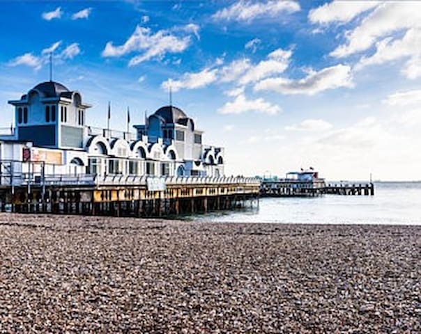
The South Parade Pier is a pier in Portsmouth, England. It is one of two piers in the city, the other being Clarence Pier. The pier once had a long hall down its centre which housed a seating area and a small restaurant. The outside of the hall is a promenade which runs the length of the pier. Once fallen into disrepair, as of 2017, the pier has been developed into an amusement arcade and food outlet.
The South Parade Pier, in Southsea, part of the English city of Portsmouth, is a pleasure pier offering typical seaside attractions including souvenir shops, ice creams, indoor amusements and a small children's funfair. It also contains a fishing deck and two function rooms which are often used for live music.
The history of the pier has been eventful; like many UK piers. Construction started in 1878 and was officially opened on 26 July 1879. The pier's pavilion was destroyed by fire on 19 July 1904. The pier was then sold to the Portsmouth corporation for £10,782. The pier officially reopened 12 August 1908. In 1914 in an attempt to improve the financial prospects of Seaview Chain Pier the Seaview steam packet company was formed and began running a service between Seaview Chain Pier and South Parade Pier. The service came a halt in September 1914 and was formally prevented from further running by the Admiralty in 1915.
It was partly dismantled during the Second World War in an attempt to hinder any invasion. It caught fire several times, most famously in 1974 during shooting of the film Tommy. In the 1980s the pier's Gaiety and Albert ballrooms were used several times a week for discos organised by Portsmouth Polytechnic students. The pier appeared in an episode of Mr. Bean entitled "Mind the Baby Mr. Bean."
The Pier was sold to three businessmen in 2010, who pledged to restore it to its former glory. The iconic pier is now owned by Frederick Nash, director of Hampshire property firm Matchams South Coast, and partners Tony Marshall, a London lawyer, and Cambridgeshire stud farm proprietor David Moore.
The deck was closed to the general public due to health and safety concerns in April 2012. Limited access was granted to people fishing, but access was withdrawn for all other potential users. At the beginning of November the pier was completely closed and fenced off by Portsmouth City Council as it was a danger to the public. A couple of days later the council reopened the front of the pier, which included part of the arcade and other bits which are on land.
In December 2012 an attempt to sell the pier at auction failed.
Parts of the boat deck at the end of South Parade Pier have been broken off after being battered by bad weather on the night of 5 February 2014, after this, the front deck of the pier was boarded up.
In April 2015 the boarding on the front deck was removed and the Ice Cream Parlour and Newsagents resumed trading. The rest of the pier remained closed to the public. There have been many efforts by local people to ask the council to buy the pier.
The Pier was finally repaired and reopened on 14 April 2017 with a refurbished amusement arcade and a cafe. Deep Blue Restaurants opened in the Summer in the former Albert Tavern building. The pier is now run by the South Parade trust which aims to acquire and improve, sustain and develop the property and business of South Parade Pier.
37 người dân địa phương đề xuất
South Parade Pier
South ParadeThe South Parade Pier is a pier in Portsmouth, England. It is one of two piers in the city, the other being Clarence Pier. The pier once had a long hall down its centre which housed a seating area and a small restaurant. The outside of the hall is a promenade which runs the length of the pier. Once fallen into disrepair, as of 2017, the pier has been developed into an amusement arcade and food outlet.
The South Parade Pier, in Southsea, part of the English city of Portsmouth, is a pleasure pier offering typical seaside attractions including souvenir shops, ice creams, indoor amusements and a small children's funfair. It also contains a fishing deck and two function rooms which are often used for live music.
The history of the pier has been eventful; like many UK piers. Construction started in 1878 and was officially opened on 26 July 1879. The pier's pavilion was destroyed by fire on 19 July 1904. The pier was then sold to the Portsmouth corporation for £10,782. The pier officially reopened 12 August 1908. In 1914 in an attempt to improve the financial prospects of Seaview Chain Pier the Seaview steam packet company was formed and began running a service between Seaview Chain Pier and South Parade Pier. The service came a halt in September 1914 and was formally prevented from further running by the Admiralty in 1915.
It was partly dismantled during the Second World War in an attempt to hinder any invasion. It caught fire several times, most famously in 1974 during shooting of the film Tommy. In the 1980s the pier's Gaiety and Albert ballrooms were used several times a week for discos organised by Portsmouth Polytechnic students. The pier appeared in an episode of Mr. Bean entitled "Mind the Baby Mr. Bean."
The Pier was sold to three businessmen in 2010, who pledged to restore it to its former glory. The iconic pier is now owned by Frederick Nash, director of Hampshire property firm Matchams South Coast, and partners Tony Marshall, a London lawyer, and Cambridgeshire stud farm proprietor David Moore.
The deck was closed to the general public due to health and safety concerns in April 2012. Limited access was granted to people fishing, but access was withdrawn for all other potential users. At the beginning of November the pier was completely closed and fenced off by Portsmouth City Council as it was a danger to the public. A couple of days later the council reopened the front of the pier, which included part of the arcade and other bits which are on land.
In December 2012 an attempt to sell the pier at auction failed.
Parts of the boat deck at the end of South Parade Pier have been broken off after being battered by bad weather on the night of 5 February 2014, after this, the front deck of the pier was boarded up.
In April 2015 the boarding on the front deck was removed and the Ice Cream Parlour and Newsagents resumed trading. The rest of the pier remained closed to the public. There have been many efforts by local people to ask the council to buy the pier.
The Pier was finally repaired and reopened on 14 April 2017 with a refurbished amusement arcade and a cafe. Deep Blue Restaurants opened in the Summer in the former Albert Tavern building. The pier is now run by the South Parade trust which aims to acquire and improve, sustain and develop the property and business of South Parade Pier.
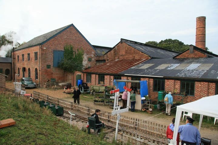
Bursledon Brickworks Industrial Museum, often shortened to Bursledon Brickworks, is a volunteer-run brickworks museum based in the village of Swanwick, Hampshire, England. It is thought to be the last Victorian steam-driven brickworks left in the UK.
The brick kiln, chimney, drying sheds, and the boiler and engine house at the south section of the brickworks are listed Grade II* as a group on the National Heritage List for England.
The Hampshire Narrow Gauge Railway Trust (HNGRT) operates a demonstration narrow-gauge railway at the brickworks. The Trust was formed in 1961 as the Hampshire Narrow Gauge Railway Society, initially to rescue a W. G. Bagnall steam locomotive from Dorothea Quarry. The society built up a collection of rolling stock and track, and based its operations at Bursledon. In 2006, the society was incorporated into the Hampshire Narrow Gauge Railway Trust.
11 người dân địa phương đề xuất
Bursledon Brickworks Industrial Museum
Swanwick LaneBursledon Brickworks Industrial Museum, often shortened to Bursledon Brickworks, is a volunteer-run brickworks museum based in the village of Swanwick, Hampshire, England. It is thought to be the last Victorian steam-driven brickworks left in the UK.
The brick kiln, chimney, drying sheds, and the boiler and engine house at the south section of the brickworks are listed Grade II* as a group on the National Heritage List for England.
The Hampshire Narrow Gauge Railway Trust (HNGRT) operates a demonstration narrow-gauge railway at the brickworks. The Trust was formed in 1961 as the Hampshire Narrow Gauge Railway Society, initially to rescue a W. G. Bagnall steam locomotive from Dorothea Quarry. The society built up a collection of rolling stock and track, and based its operations at Bursledon. In 2006, the society was incorporated into the Hampshire Narrow Gauge Railway Trust.
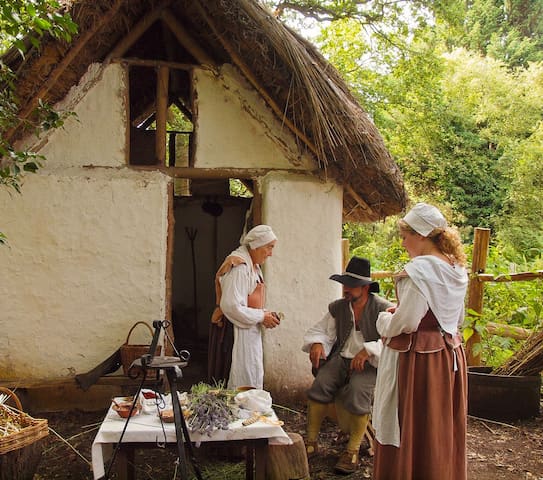
Little Woodham, also known as "The Living History Village of Little Woodham" or "The Seventeenth Century Village", is a living museum dedicated to recreating life in a rural village in the mid-17th century. It is situated in ancient woodland in Rowner, on the Gosport peninsula, Hampshire.
The hamlet of Little Woodham was initially created in 1984 as a temporary reenactment of village life on the eve of the English Civil War by members of The English Civil War Society as part of their enactment of the fictional Battle Of Stokes Bay. Following this, Society volunteers continued the exhibition during the summers of 1984 and 1985.
When the English Civil War Society announced they would be unable to continue, local residents formed the Gosport Living History Society to take over the running of the village to preserve it as an educational resource and tourist attraction. The Gosport Borough Council provided much of the financing and administration until 1995 when the Gosport Living History Society became a registered charity and took on sole responsibility for funding and administration, and in 2007, Little Woodham won the "Best Leisure & Tourism Venue" in the "Go Gosport".
Little Woodham has the only 17th Century replica pottery kiln in the world, carefully reconstructed using the same materials and techniques. It was fired for the first time in 2015 and has been fired each year since with all the pottery made using the kick wheel turntable in the 17th Century Pottery.
The 17th Century coal forge was recreated using evidence gathered from an archaeological dig of a *seventeenth-century blacksmith shop at Ferryland, Newfoundland (built 1622) and from various *paintings and etchings from the period. Although the forge is a recreation, the artefacts anvils and tools used in the forge are hundreds of years old, so the sounds and smell of the coal forge is as close as you will ever get to being in a forge in the 17th century.
17th century coal forge and English 5th foot anvil
Little Woodham also run frequent 17th-Century Forge Experience days for visitors to spend a day working in the 17th Century coal forge, guided by Little Woodham's blacksmith to recreate 17th-century iron work and learning traditional techniques and skills using steel and wrought iron, and look at the real 17th-century examples.
There are a number of other trades and crafts throughout the village, including weavers and wool dyers, a wood turner, button maker, apothecarist, scribe, trickster and barber surgeon and many more.
20 người dân địa phương đề xuất
Little Woodham Living History Village
Barrington CloseLittle Woodham, also known as "The Living History Village of Little Woodham" or "The Seventeenth Century Village", is a living museum dedicated to recreating life in a rural village in the mid-17th century. It is situated in ancient woodland in Rowner, on the Gosport peninsula, Hampshire.
The hamlet of Little Woodham was initially created in 1984 as a temporary reenactment of village life on the eve of the English Civil War by members of The English Civil War Society as part of their enactment of the fictional Battle Of Stokes Bay. Following this, Society volunteers continued the exhibition during the summers of 1984 and 1985.
When the English Civil War Society announced they would be unable to continue, local residents formed the Gosport Living History Society to take over the running of the village to preserve it as an educational resource and tourist attraction. The Gosport Borough Council provided much of the financing and administration until 1995 when the Gosport Living History Society became a registered charity and took on sole responsibility for funding and administration, and in 2007, Little Woodham won the "Best Leisure & Tourism Venue" in the "Go Gosport".
Little Woodham has the only 17th Century replica pottery kiln in the world, carefully reconstructed using the same materials and techniques. It was fired for the first time in 2015 and has been fired each year since with all the pottery made using the kick wheel turntable in the 17th Century Pottery.
The 17th Century coal forge was recreated using evidence gathered from an archaeological dig of a *seventeenth-century blacksmith shop at Ferryland, Newfoundland (built 1622) and from various *paintings and etchings from the period. Although the forge is a recreation, the artefacts anvils and tools used in the forge are hundreds of years old, so the sounds and smell of the coal forge is as close as you will ever get to being in a forge in the 17th century.
17th century coal forge and English 5th foot anvil
Little Woodham also run frequent 17th-Century Forge Experience days for visitors to spend a day working in the 17th Century coal forge, guided by Little Woodham's blacksmith to recreate 17th-century iron work and learning traditional techniques and skills using steel and wrought iron, and look at the real 17th-century examples.
There are a number of other trades and crafts throughout the village, including weavers and wool dyers, a wood turner, button maker, apothecarist, scribe, trickster and barber surgeon and many more.
Gosport is located on the western side of Portsmouth Harbour which, by the seventeenth century, was increasingly being used as a base by the Royal Navy. Although the main docks were in Portsmouth, the naval presence also led to the expansion of Gosport with some of the dockyard facilities built in the town. In 1677 Gosport was enclosed by an earth rampart fronted with a dry moat. In the 1680s two artillery blockhouses - Fort Charles and Fort James (Burrow Island) - were constructed. These were replaced in 1748 by the Gosport Lines, a substantial bastioned rampart fronted by a ditch. These defences remained extant until the mid-nineteenth century. However, in 1852 Napoleon III became Emperor of France prompting fears of a resumption of the Napoleonic Wars. The situation deteriorated in 1858 when France launched the world's first seagoing ironclad warship ('La Gloire'; the Glory) – an armoured vessel outclassed anything in the Royal Navy and threatened Britain’s maritime superiority. Britain, in a state of panic, initiated a Royal Commission to make recommendations on coastal defence. However, before the Commission stood up, defensive plans devised by Colonel William Jervois, Assistant Inspection General of Fortifications were put in motion for the protection of Portsmouth Harbour. The plans included construction of the Gosport Advanced Lines, a series of polygonal land defence forts, located around two miles from the waterfront and intended to prevent an enemy force proceeding down the Gosport peninsula and bombarding the dockyard. Fort Brockhurst was one of five facilities in this line (the others were Fort Elson, Fort Rowner, Fort Grange and Fort Gomer).
Work started on Fort Brockhurst on 31 March 1858 and continued through to completion on 20 December 1862. It was laid out in polygonal arrangement which reflected the latest military doctrine and replaced the bastioned design of earlier forts such as the Royal Citadel. Instead, each fort operated in conjunction with its neighbours and was able to provide supporting fire across the front of the adjacent outposts. Like its identical forts at Grange and Rowner, Fort Brockhurst was designed for an armament of 50 guns although only a portion was ever installed; a report dated 1893 listed eight 7-inch Rifled Breach Loading guns, nine 64-pounder Rifled Muzzle Loading guns and two 0.45-inch Machine Guns. The fort's earth topped rampart was built over casemated barracks that provided accommodation for a garrison of 308 men. Two ramps provided access to the terreplein. Surrounding the fort was a wet ditch which was covered by three caponiers. A triangular shaped salient, known as a redan, extended to the north and was intended to provide flanking fire against any attacking force. A circular Keep, also surrounded by a wet ditch, was located to the rear and redesigned to act as a redoubt should the fort be overrun.
Even before Fort Brockhurst was completed, concerns were being expressed that it was built in the wrong place. Developments in artillery meant that the location of Fort Brockhurst and her sister outposts were simply too close to the dockyard and would be unable to prevent an overland attack getting into effective artillery range of the dockyard. Accordingly the findings of the Royal Commission proposed construction of the Gosport Outer Lines, a series of three forts located two miles in advance of the existing forts. In the end only one of these new outposts - Fort Fareham - was actually constructed as the Government balked at the idea of decommissioning brand new facilities built at vast taxpayer expense. Accordingly Fort Brockhurst, along with her sister forts of the Gosport Advanced Line, remained in commission. The invasion fears came to nothing and thereafter the fort simply served as a base for a variety of military units and as a depot. During World War I it was used as a recruitment and de-mobilisation centre. During World War II it provided transit accommodation and suffered some minor bomb damage during an air-raid. The military disposed of the site in 1957 and it is now in the care of English Heritage.
Although modern life has encroached on the fort, its fabric remains largely unaltered and the parade ground, gun ramps and moated keep can all be viewed. Constructional details of the casemates are able to be seen due to unrepaired Second World War bomb damage at the North-East corner. It is currently used as a store for English Heritage's reserve collections. The site is occasionally open to the public.
The polygonal shape of the fort was a revolutionary change from the prevailing orthodoxy of forts designed with angle bastions for defence. The new forts could be more easily adapted to the terrain and allowed a greatly increased number of heavy guns mounted on the ramparts to prioritise offence over defence. Each fort was located within gunshot of the next to allow overlapping fields of fire and mutual support.
The fort was surrounded by a moat and the entrance on the south-east side was approached by a drawbridge much like a medieval castle. This led to a circular keep, also moated, served as a place for local defence, being equipped with twenty light guns. The nineteen heavy guns of the main armament were mounted on the ramparts reached by two ramps on the enclosed parade ground in the middle of the fort. A lower tier of eight guns, four in casements, on each flank provided cross fire support with Elson and Rowner. Beyond the moat on the north side was a triangular redan accessed by a covered way to allow riflemen to cover attempts to bridge the moat. Similarly there were caponiers at the angles of the ramparts to allow riflemen to cover the moat.
Fort Brockhurst
Gunners WayGosport is located on the western side of Portsmouth Harbour which, by the seventeenth century, was increasingly being used as a base by the Royal Navy. Although the main docks were in Portsmouth, the naval presence also led to the expansion of Gosport with some of the dockyard facilities built in the town. In 1677 Gosport was enclosed by an earth rampart fronted with a dry moat. In the 1680s two artillery blockhouses - Fort Charles and Fort James (Burrow Island) - were constructed. These were replaced in 1748 by the Gosport Lines, a substantial bastioned rampart fronted by a ditch. These defences remained extant until the mid-nineteenth century. However, in 1852 Napoleon III became Emperor of France prompting fears of a resumption of the Napoleonic Wars. The situation deteriorated in 1858 when France launched the world's first seagoing ironclad warship ('La Gloire'; the Glory) – an armoured vessel outclassed anything in the Royal Navy and threatened Britain’s maritime superiority. Britain, in a state of panic, initiated a Royal Commission to make recommendations on coastal defence. However, before the Commission stood up, defensive plans devised by Colonel William Jervois, Assistant Inspection General of Fortifications were put in motion for the protection of Portsmouth Harbour. The plans included construction of the Gosport Advanced Lines, a series of polygonal land defence forts, located around two miles from the waterfront and intended to prevent an enemy force proceeding down the Gosport peninsula and bombarding the dockyard. Fort Brockhurst was one of five facilities in this line (the others were Fort Elson, Fort Rowner, Fort Grange and Fort Gomer).
Work started on Fort Brockhurst on 31 March 1858 and continued through to completion on 20 December 1862. It was laid out in polygonal arrangement which reflected the latest military doctrine and replaced the bastioned design of earlier forts such as the Royal Citadel. Instead, each fort operated in conjunction with its neighbours and was able to provide supporting fire across the front of the adjacent outposts. Like its identical forts at Grange and Rowner, Fort Brockhurst was designed for an armament of 50 guns although only a portion was ever installed; a report dated 1893 listed eight 7-inch Rifled Breach Loading guns, nine 64-pounder Rifled Muzzle Loading guns and two 0.45-inch Machine Guns. The fort's earth topped rampart was built over casemated barracks that provided accommodation for a garrison of 308 men. Two ramps provided access to the terreplein. Surrounding the fort was a wet ditch which was covered by three caponiers. A triangular shaped salient, known as a redan, extended to the north and was intended to provide flanking fire against any attacking force. A circular Keep, also surrounded by a wet ditch, was located to the rear and redesigned to act as a redoubt should the fort be overrun.
Even before Fort Brockhurst was completed, concerns were being expressed that it was built in the wrong place. Developments in artillery meant that the location of Fort Brockhurst and her sister outposts were simply too close to the dockyard and would be unable to prevent an overland attack getting into effective artillery range of the dockyard. Accordingly the findings of the Royal Commission proposed construction of the Gosport Outer Lines, a series of three forts located two miles in advance of the existing forts. In the end only one of these new outposts - Fort Fareham - was actually constructed as the Government balked at the idea of decommissioning brand new facilities built at vast taxpayer expense. Accordingly Fort Brockhurst, along with her sister forts of the Gosport Advanced Line, remained in commission. The invasion fears came to nothing and thereafter the fort simply served as a base for a variety of military units and as a depot. During World War I it was used as a recruitment and de-mobilisation centre. During World War II it provided transit accommodation and suffered some minor bomb damage during an air-raid. The military disposed of the site in 1957 and it is now in the care of English Heritage.
Although modern life has encroached on the fort, its fabric remains largely unaltered and the parade ground, gun ramps and moated keep can all be viewed. Constructional details of the casemates are able to be seen due to unrepaired Second World War bomb damage at the North-East corner. It is currently used as a store for English Heritage's reserve collections. The site is occasionally open to the public.
The polygonal shape of the fort was a revolutionary change from the prevailing orthodoxy of forts designed with angle bastions for defence. The new forts could be more easily adapted to the terrain and allowed a greatly increased number of heavy guns mounted on the ramparts to prioritise offence over defence. Each fort was located within gunshot of the next to allow overlapping fields of fire and mutual support.
The fort was surrounded by a moat and the entrance on the south-east side was approached by a drawbridge much like a medieval castle. This led to a circular keep, also moated, served as a place for local defence, being equipped with twenty light guns. The nineteen heavy guns of the main armament were mounted on the ramparts reached by two ramps on the enclosed parade ground in the middle of the fort. A lower tier of eight guns, four in casements, on each flank provided cross fire support with Elson and Rowner. Beyond the moat on the north side was a triangular redan accessed by a covered way to allow riflemen to cover attempts to bridge the moat. Similarly there were caponiers at the angles of the ramparts to allow riflemen to cover the moat.
Four Forts Cream Tea Cruise
A three hour cruise taking in Horse Sand, No Man’s Land, Spitbank and St Helen’s forts.
All four forts were designed and built in the 19th century by Lord Palmerston to protect the eastern approaches to Portsmouth Harbour. The cruise finishes with a grand tour of Portsmouth Harbour.
Cream teas purchased on the day charged at £4.95 (£3.75 child).
26 người dân địa phương đề xuất
Gosport Ferry station
Four Forts Cream Tea Cruise
A three hour cruise taking in Horse Sand, No Man’s Land, Spitbank and St Helen’s forts.
All four forts were designed and built in the 19th century by Lord Palmerston to protect the eastern approaches to Portsmouth Harbour. The cruise finishes with a grand tour of Portsmouth Harbour.
Cream teas purchased on the day charged at £4.95 (£3.75 child).
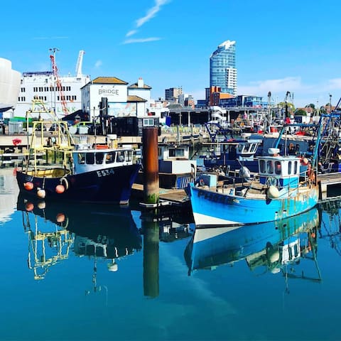
Camber Dock is the oldest developed part of the Portsmouth Harbour complex. Lying within the historic area of Old Portsmouth, it is part of Portsmouth Point that lies outside the original fortified boundaries of Portsmouth. After improvements in the King James's and Landport Gates and the areas military defences, civilian building of dockside storage and ancillary servicing facilities began from 1590. With major ships anchored at Spithead, from the 18th century the surrounding area became noted as a popular but lewd area for visiting sailors.
With advent of bigger steam powered ships, the physical restrictions of Camber Dock meant that it was bypassed for the larger capacity of the newer developed Portsmouth Harbour. Resultantly, Camber Quay became the home of the local fishing fleet, which it still remains today, together with the adjacent dockside development of the commercial fish market. Today it also has a series of visiting berths for non-commercial craft. In 2015, the Land Rover BAR yacht racing headquarters was completed.
The Camber Docks
White Hart RoadCamber Dock is the oldest developed part of the Portsmouth Harbour complex. Lying within the historic area of Old Portsmouth, it is part of Portsmouth Point that lies outside the original fortified boundaries of Portsmouth. After improvements in the King James's and Landport Gates and the areas military defences, civilian building of dockside storage and ancillary servicing facilities began from 1590. With major ships anchored at Spithead, from the 18th century the surrounding area became noted as a popular but lewd area for visiting sailors.
With advent of bigger steam powered ships, the physical restrictions of Camber Dock meant that it was bypassed for the larger capacity of the newer developed Portsmouth Harbour. Resultantly, Camber Quay became the home of the local fishing fleet, which it still remains today, together with the adjacent dockside development of the commercial fish market. Today it also has a series of visiting berths for non-commercial craft. In 2015, the Land Rover BAR yacht racing headquarters was completed.
The Point Portsmouth consists of just a few acres around the camber in Old Portsmouth but is bursting with history and character at every step.
The Point is also known as the Spice Island, the origins of its name lost in the dim past. Maybe it referred to the smell of spices being unloaded or a reference to the spicier side of life on The Point..
The area was separated from the city by King Jame’s Gate and was filled with eating houses, cookshops, drinking establishments, pawn shops, brothels, tailors and all manner of services, fulfilling the needs of all those who had business with the sea. Because The Point was outside of the city it wasn’t subject to the bylaws of the city and therefore the drinking dens could stay open all day. There were numerous drinking dens and coffee houses in Portsmouth as a whole but half of them were crammed onto the land at The Point.
It was an area notoriously dangerous, where mugging and rioting were common place, prostitution rife, press gangs roamed and filth and disease a constant companion and yet it drew a remarkable company of men and women, noble and vagrant, jostling for business or part of the great Royal Navy.
Maybe it is the narrow cobbled streets and pubs or the bustle of fishing boats, ferries, pilot boats and yachts but The Point has a timeless feel to it and is the perfect spot to immerse yourself in a little of Portsmouth’s amazing history.
The Point
3B Bath SquareThe Point Portsmouth consists of just a few acres around the camber in Old Portsmouth but is bursting with history and character at every step.
The Point is also known as the Spice Island, the origins of its name lost in the dim past. Maybe it referred to the smell of spices being unloaded or a reference to the spicier side of life on The Point..
The area was separated from the city by King Jame’s Gate and was filled with eating houses, cookshops, drinking establishments, pawn shops, brothels, tailors and all manner of services, fulfilling the needs of all those who had business with the sea. Because The Point was outside of the city it wasn’t subject to the bylaws of the city and therefore the drinking dens could stay open all day. There were numerous drinking dens and coffee houses in Portsmouth as a whole but half of them were crammed onto the land at The Point.
It was an area notoriously dangerous, where mugging and rioting were common place, prostitution rife, press gangs roamed and filth and disease a constant companion and yet it drew a remarkable company of men and women, noble and vagrant, jostling for business or part of the great Royal Navy.
Maybe it is the narrow cobbled streets and pubs or the bustle of fishing boats, ferries, pilot boats and yachts but The Point has a timeless feel to it and is the perfect spot to immerse yourself in a little of Portsmouth’s amazing history.
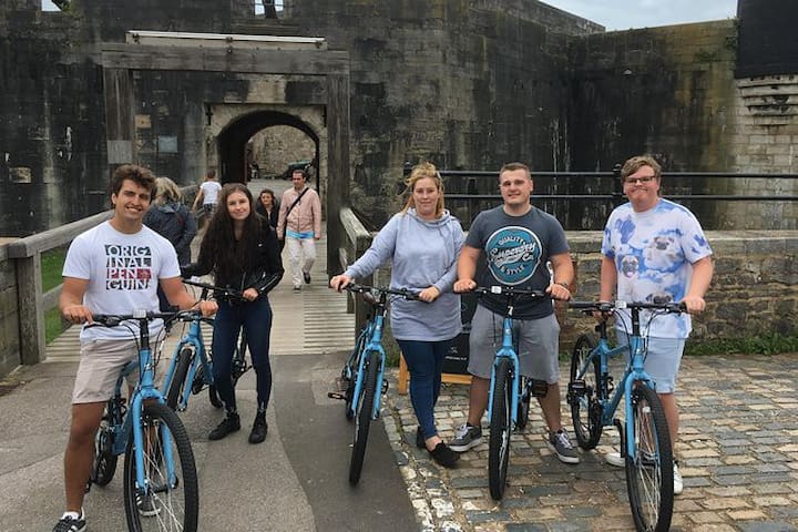
GRAND BIKE TOUR OF PORTSMOUTH.
Prepare for an entertaining guided bike tour of the city of Portsmouth. As well as centuries of amazing naval history, discover what else this island city has to offer.
Departure Point: 7 The Hard, Portsmouth PO1 3EA, UK
Duration: 2h 30m
Return Details: Returns to original departure point
Inclusions: Use of bicycle, Helmet (Optional).
The Hard
The HardGRAND BIKE TOUR OF PORTSMOUTH.
Prepare for an entertaining guided bike tour of the city of Portsmouth. As well as centuries of amazing naval history, discover what else this island city has to offer.
Departure Point: 7 The Hard, Portsmouth PO1 3EA, UK
Duration: 2h 30m
Return Details: Returns to original departure point
Inclusions: Use of bicycle, Helmet (Optional).
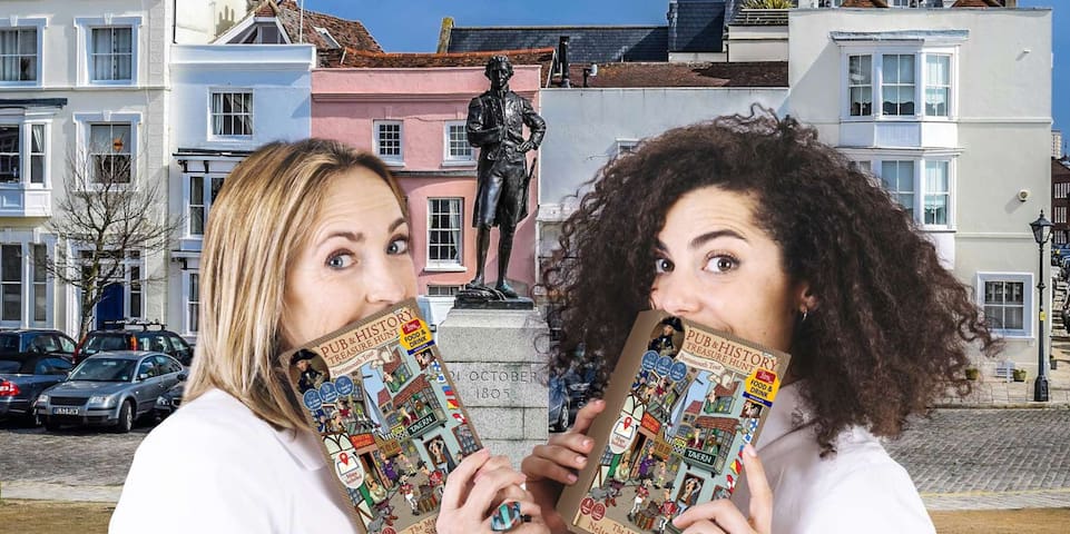
The Mystery of Nelson's Stolen Diamonds: Old Portsmouth Treasure Hunt Adventure...
Turn the historic streets of Old Portsmouth into the world's largest escape room with this self-guided treasure hunt adventure!
Solve a range of cryptic clues including word games, maths puzzles, and hidden objects, as you unravel the historic mystery and discover the identity of the infamous diamond thief!
'The perfect blend of Portsmouth, puzzles, and history!'
On Horatio Nelson's last day on dry land before joining his ship to fight in the Battle of Trafalgar, he stored a valuable diamond necklace in a chest in one of Portsmouth many taverns for safekeeping. That night, the tavern was broken into and the necklace was stolen. You must solve the clues, eliminate suspects, and return to the scene of the crime to get to the bottom of this historic mystery. This treasure hunt is the best way to see the key historic sights of the city, visit its most atmospheric taverns, and soak up true local stories of its most notorious characters and places.
What to Expect
Itinerary: Discover tales of drunkenness, murder, and treason as you hunt the historic streets & taverns of Old Portsmouth for a mysterious diamond thief in this self-guided treasure hunt adventure!
Start any time you like... simply collect the treasure hunt activity book from The Dolphin pub in Old Portsmouth and away you go!
- Walking distance: 3km
- Duration: 2-3 hours
Includes:
- 15% off food & drink in The Wellington pub (currently not selling alcohol, but is open for food and soft drinks as normal).
- 10% off food & drink in The Dolphin pub.
Important Information
Departure Point
The Dolphin, 41 High St, Old Portsmouth, Portsmouth PO1 2LU, UK
Duration: 2h 30m
Return Details: Returns to original departure point
Inclusions: 44-page colour activity booklet containing all puzzles, clues, and maps
15% off food & drink in The Wellington pub (currently not serving alcohol).
10% off food & drink in The Dolphin pub.
Full of amazing local history stories
5 traditional taverns en route
Exclusions: Alcoholic Beverages
Guide
6 người dân địa phương đề xuất
The Dolphin
41 High StThe Mystery of Nelson's Stolen Diamonds: Old Portsmouth Treasure Hunt Adventure...
Turn the historic streets of Old Portsmouth into the world's largest escape room with this self-guided treasure hunt adventure!
Solve a range of cryptic clues including word games, maths puzzles, and hidden objects, as you unravel the historic mystery and discover the identity of the infamous diamond thief!
'The perfect blend of Portsmouth, puzzles, and history!'
On Horatio Nelson's last day on dry land before joining his ship to fight in the Battle of Trafalgar, he stored a valuable diamond necklace in a chest in one of Portsmouth many taverns for safekeeping. That night, the tavern was broken into and the necklace was stolen. You must solve the clues, eliminate suspects, and return to the scene of the crime to get to the bottom of this historic mystery. This treasure hunt is the best way to see the key historic sights of the city, visit its most atmospheric taverns, and soak up true local stories of its most notorious characters and places.
What to Expect
Itinerary: Discover tales of drunkenness, murder, and treason as you hunt the historic streets & taverns of Old Portsmouth for a mysterious diamond thief in this self-guided treasure hunt adventure!
Start any time you like... simply collect the treasure hunt activity book from The Dolphin pub in Old Portsmouth and away you go!
- Walking distance: 3km
- Duration: 2-3 hours
Includes:
- 15% off food & drink in The Wellington pub (currently not selling alcohol, but is open for food and soft drinks as normal).
- 10% off food & drink in The Dolphin pub.
Important Information
Departure Point
The Dolphin, 41 High St, Old Portsmouth, Portsmouth PO1 2LU, UK
Duration: 2h 30m
Return Details: Returns to original departure point
Inclusions: 44-page colour activity booklet containing all puzzles, clues, and maps
15% off food & drink in The Wellington pub (currently not serving alcohol).
10% off food & drink in The Dolphin pub.
Full of amazing local history stories
5 traditional taverns en route
Exclusions: Alcoholic Beverages
Guide
DISCOVERY FLIGHT AROUND PORTSMOUTH
Go on an unforgettable adventure and discover the beauty of Portsmouth and the surrounding area in the most unique way...from a private micro plane!
You’ll see stunning views of the city, Isle of Wight, Spinnaker Tower...and many more sights for you to discover with a local pilot!
Your pilot is key to this adventure. They are sharing the flights' direct cost, not making a profit. They just love to fly and want you to understand their passion for aviation.
So be sure to meet your pilot directly at Lee-on-the-Solent airport.
++Confirm weather conditions with your pilot before++ --> Access a local airfield --> Discuss the flight route together with your pilot --> Pre-flight check --> Up you go, enjoy the view from a whole new perspective!
The flight can depart between 9-17h, depending on the availability of the pilot, aircraft, and weather. Please let us know your flexible hours/days upon booking, and make sure that you've been in touch with us beforehand!
You'll start at
Solent Airport, Daedalus Drive, Lee-on-the-Solent PO13 9FZ, UK
Pass by
Portsmouth
Bournemouth
Isle of Wight
Spinnaker Tower
Portsmouth Harbour
HMS Victory
HMS Warrior 1860
Port Solent
You'll end at Solent Airport.

Solent Airport
Daedalus DriveDISCOVERY FLIGHT AROUND PORTSMOUTH
Go on an unforgettable adventure and discover the beauty of Portsmouth and the surrounding area in the most unique way...from a private micro plane!
You’ll see stunning views of the city, Isle of Wight, Spinnaker Tower...and many more sights for you to discover with a local pilot!
Your pilot is key to this adventure. They are sharing the flights' direct cost, not making a profit. They just love to fly and want you to understand their passion for aviation.
So be sure to meet your pilot directly at Lee-on-the-Solent airport.
++Confirm weather conditions with your pilot before++ --> Access a local airfield --> Discuss the flight route together with your pilot --> Pre-flight check --> Up you go, enjoy the view from a whole new perspective!
The flight can depart between 9-17h, depending on the availability of the pilot, aircraft, and weather. Please let us know your flexible hours/days upon booking, and make sure that you've been in touch with us beforehand!
You'll start at
Solent Airport, Daedalus Drive, Lee-on-the-Solent PO13 9FZ, UK
Pass by
Portsmouth
Bournemouth
Isle of Wight
Spinnaker Tower
Portsmouth Harbour
HMS Victory
HMS Warrior 1860
Port Solent
You'll end at Solent Airport.
TALKING TELESCOPE.
Tourist Telescopes have installed versions of this telescope in many of the U.K.’s top tourist attractions as well as castles, zoos, museums, historic houses and of course the traditional seafront promenades. This is just one of a number in Southsea and is situated upon the small hill between Southsea Castle and the Pyramids. It looks out onto the Isle of Wight and the Forts.
With the versatility of being able to provide commentaries in different languages they open up new options for foreign visitors to gain knowledge about the views.
The coin mechanisms take multiple coins & can have an extended view option to increase your vend price opportunity.
They can be programmed to accept most foreign currency.
Multiple commentaries or foreign languages can be provided.
The height of the column can be modified to be even more child friendly of more accessible for wheel chair access.

Castle Field
Clarence EsplanadeTALKING TELESCOPE.
Tourist Telescopes have installed versions of this telescope in many of the U.K.’s top tourist attractions as well as castles, zoos, museums, historic houses and of course the traditional seafront promenades. This is just one of a number in Southsea and is situated upon the small hill between Southsea Castle and the Pyramids. It looks out onto the Isle of Wight and the Forts.
With the versatility of being able to provide commentaries in different languages they open up new options for foreign visitors to gain knowledge about the views.
The coin mechanisms take multiple coins & can have an extended view option to increase your vend price opportunity.
They can be programmed to accept most foreign currency.
Multiple commentaries or foreign languages can be provided.
The height of the column can be modified to be even more child friendly of more accessible for wheel chair access.
TREADGOLD FISH SCULPTURE.
The Treadgold Fish Sculpture was created by local artist Pete Codling. Made of scrap metal to collect plastic bottles, it moves around the icon locations of Portsmouth asking people to help bury the man on his phone in the middle of the artwork.
Currently located on the promenade beside "The Briny "restaurant.
27 người dân địa phương đề xuất
The Briny
Clarence EsplanadeTREADGOLD FISH SCULPTURE.
The Treadgold Fish Sculpture was created by local artist Pete Codling. Made of scrap metal to collect plastic bottles, it moves around the icon locations of Portsmouth asking people to help bury the man on his phone in the middle of the artwork.
Currently located on the promenade beside "The Briny "restaurant.